

Most cities don’t know how many miles of sidewalk they have, making it hard for public works departments to plan and engineering consultants to submit accurate bids. To help, DeepWalk built a free sidewalk mileage calculator using OpenStreetMap data. However, knowing how much sidewalk exists is only the first step. OpenStreetMap is a useful mapping tool, not a condition inventory, and understanding the difference helps cities choose the right tools for maintenance planning. It tells you where the sidewalks are, but DeepWalk tells you their condition. Together, they give cities the full picture needed for condition assessments and maintenance planning.
OpenStreetMap was launched in 2004 with a simple premise: the world deserves a free, editable map that anyone can contribute to and anyone can use. Built by volunteers using GPS traces, aerial imagery, and local knowledge, it has grown into one of the most comprehensive sources of street-level infrastructure data in the world. OpenSidewalks is a University of Washington research initiative that extended OpenStreetMap specifically for pedestrian infrastructure. Where OpenStreetMap maps the world broadly, OpenSidewalks developed a structured tagging schema for sidewalks, crossings, and curbs, standardizing how pedestrian pathways are described so the data can be used reliably. Together, they form a strong dataset for understanding where pedestrian infrastructure exists. But knowing where sidewalks are is different from knowing what condition they are in, which is where DeepWalk helps.
OpenStreetMap and OpenSidewalks capture network geometry, mileage estimates, and pedestrian routing, while standardizing the tagging structure to identify everything from pedestrian walkways to pathways and footways. For cities trying to understand the rough size and shape of their pedestrian network, this is a useful starting point before any fieldwork begins.
Where OpenStreetMap stops is in the details. Surface condition, cross slope, trip hazards, and vertical obstructions require someone to walk the network and measure it. That is the gap DeepWalk is made to fill. The free mileage calculator gives you a quick baseline from OpenStreetMap data, and DeepWalk fills in everything the map can't tell you: condition grades, slope measurements, and defect locations down to the individual panel.
Coverage also varies by city, which is another reason for field verification with DeepWalk. A city might query its OpenStreetMap data and get a reasonable mileage estimate, but ground-truthing that number with DeepWalk ensures the inventory is complete and accurate to build effective programs.
For a comprehensive sidewalk inventory, mileage is a starting point. A complete sidewalk inventory features four things: condition data, access data, ownership records, and verified mileage. Condition data includes cross and run slopes, clear widths, areas, and deterioration at the panel level. Access data includes the type and presence of a detectable warning surface, ramp type, and ramp or midblock material. Ownership records are the delineation of public versus private sidewalk and municipal-owned versus state-owned. Verified mileage is confirmed in the field by measuring every sidewalk segment. Municipalities need these features to build impactful programs for capital planning, ADA transition plans, and broader pedestrian infrastructure improvements. DeepWalk is built to collect all of it in a single field inspection.
DeepWalk's free sidewalk mileage calculator is the fastest way to get a network estimate before any field work begins. Enter a city or municipality and the calculator queries OpenStreetMap data, pulling from the same volunteer-built network that OpenSidewalks helped standardize, to return a mileage figure in seconds. That number provides public works departments with a baseline for planning and gives engineering consultants a scoping tool for building accurate project bids. From there, DeepWalk takes over. Using iPhone LiDAR, field staff collect a comprehensive sidewalk inventory at the panel level. All data is delivered via DeepWalk's web application, including ArcGIS integrations and downloadable files, and plugs directly into the GIS workflows most municipalities are already running. The result is a clear map from network estimate to comprehensive inspection to work order generation.
Consider a mid-sized city preparing a sidewalk self-evaluation. The public works director runs the city through DeepWalk's mileage calculator and gets an estimate of 180 miles of sidewalk. That figure is enough to scope the project, secure budget approval, and brief the city council. DeepWalk then verifies and expands that estimate through direct measurement, collecting condition grades, cross slopes, and curb ramp data. The final verified mileage comes in at 187 miles, with a full condition and access dataset attached. That dataset feeds directly into the self-evaluation, prioritizing repairs, estimating remediation costs, and creating a record the city can act on. Then, using DeepWalk, the public works director creates hazard removal programs and generates work orders to make real improvements in their community.
OpenStreetMap and OpenSidewalks have made pedestrian network data more accessible than ever before. For cities that previously had no idea how much sidewalk they had, a free mileage estimate is a meaningful starting point. But a map is not a plan. Capital improvement programs, transition plans, and pedestrian infrastructure investments require field-verified condition and access data that no volunteer mapping platform can provide. DeepWalk is built to collect it. Start with the free sidewalk mileage calculator to see how much sidewalk your city has today, then take the next step toward a complete inventory.
Map the current sidewalk mileage in your city, town, neighborhood, or custom area. Our new mileage tool pulls accurate sidewalk information, allowing you to plan efficiently, budget effectively, and determine the amount of data collectors for your project. The data is sourced from OpenStreetMap, a free, collaborative mapping platform built and maintained by contributors worldwide.
Get A Free Mileage Estimate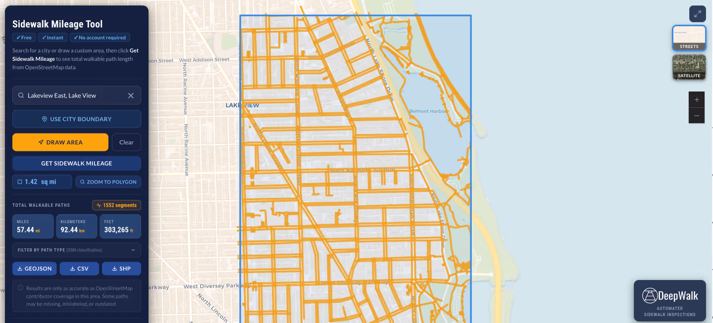
.avif)
DeepWalk is the sidewalk inspection solution trusted by 120+ municipalities and consultants nationwide.
© 2026 DeepWalk Research, Inc.
All rights reserved.